
If you are picturing a move to Vancouver Island, the stretch we work in sits roughly in the middle of the Island, an area generally called Central Vancouver Island. Nanaimo is the hub of that region, the largest city and the easiest place to reach by ferry or air, but the area itself covers more than twenty distinct communities.
Where you land inside that region changes more than your commute. It changes whether your Saturday starts with a beach walk or a downtown coffee, and whether Costco is fifteen minutes away or fifty. We built an interactive map that lets you compare all of that side by side, the vibe, who tends to settle there, and real drive times to ferries, airports, and the shops you actually use. This post is the short version. The map is where you go deep.
Tap the map below to explore all 21 communities.
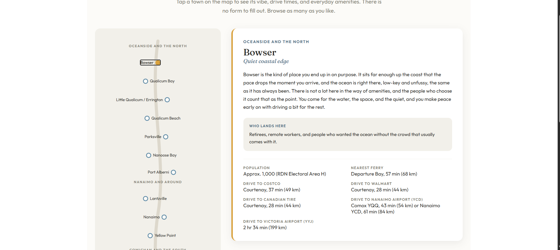
Many of the people we work with start out picturing one town, then land somewhere they had not considered once they see the full picture laid out next to each other. That is exactly what the map is for.
Where is Central Vancouver Island?
Central Vancouver Island runs from the Oceanside beach towns in the north, down through Nanaimo, and south into the Cowichan Valley. Nanaimo anchors the region as its hub city, but Central Vancouver Island as a whole covers more than twenty communities, each with a different pace and price point.
Is there one best community on Central Vancouver Island?
No. The right community depends on what your week actually needs to look like, not on any ranking. A quiet acreage and a walkable downtown condo can both be the right answer, just for different people.
The communities we cover run from Bowser in the north to Lake Cowichan in the south, grouped into three broad areas so you can narrow things down before you compare individual towns.
The three broad areas of Central Vancouver Island
Oceanside and the north
Beach towns and a slower pace, drawing people who want water close by and are willing to trade some convenience for it.
Nanaimo and around
The hub. The widest mix of home types and the shortest drive to the hospital, the ferries, and the airport.
Cowichan and the south
More rural character and generally more land for the dollar, with a longer drive north for some services.
None of this is the full comparison, just the shape of it. The map fills in each town's actual feel, who tends to settle there, and the numbers behind the drive times.
What actually decides where you land
Most people sort themselves out once they weigh a handful of the same questions.
- How much a longer ferry or highway drive actually bothers you, versus how often you would make that trip
- Whether you want a walkable town core or space and privacy around the house
- How close you need to be to health care and the hospital
- What your budget buys in each area, since it is rarely the same home for the same price
- The pace of life you are actually looking for, not the one that sounds good on paper
Frequently asked questions
Where is Central Vancouver Island?
Central Vancouver Island runs from the Oceanside beach towns in the north down through Nanaimo and south into the Cowichan Valley. Nanaimo is the hub city, with more than twenty communities across the wider region, each with its own pace and price point.
How many communities does the map cover?
The map covers 21 communities from Bowser in the north to Lake Cowichan in the south, grouped into Oceanside and the north, Nanaimo and around, and Cowichan and the south.
Do I need to pick one community before I start looking at homes?
No. Most people narrow it to two or three areas first, then let the actual homes on the market help make the final call.
What does the map actually show for each town?
Each town shows its general vibe, who tends to settle there, population, and real drive times to ferries, airports, Costco, Walmart, and Canadian Tire.
Is Nanaimo itself included, or only the surrounding towns?
Nanaimo is included alongside the surrounding communities, since for many people it is one of the options they are weighing against a smaller town nearby.
Does the map cost anything to use?
No. It is open to browse, with no form to fill out first.
Ready to compare communities directly?
The Which Community Fits You map is the fastest way to see how these places actually compare. If you want to talk through what you are weighing, you can also book a quick call with Travis or Kiel, or start with the Nanaimo Relocation Guide.